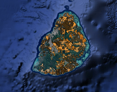
Land Suitability (Agricultural Potential) Map of Mauritius 2025
Produced by the Mauritius Sugarcane Industry Research Institute
Under the aegis of Ministry of Agro Industry, Food Security, Blue Economy and Fisheries
Disclaimer
This map has been compiled using available and new databases available at the MSIRI and using Object-Based Image Analysis (OBIA) techniques, and Artificial Intelligence (AI). While every effort has been made to ensure accuracy, the information is provided for reference purposes (agricultural potential) only and will be subject to updates. For further information, kindly contact the MSIRI (contact@msiri.mu).
Contact us